
Outdoors
Zion Narrows Bottom-Up Hike
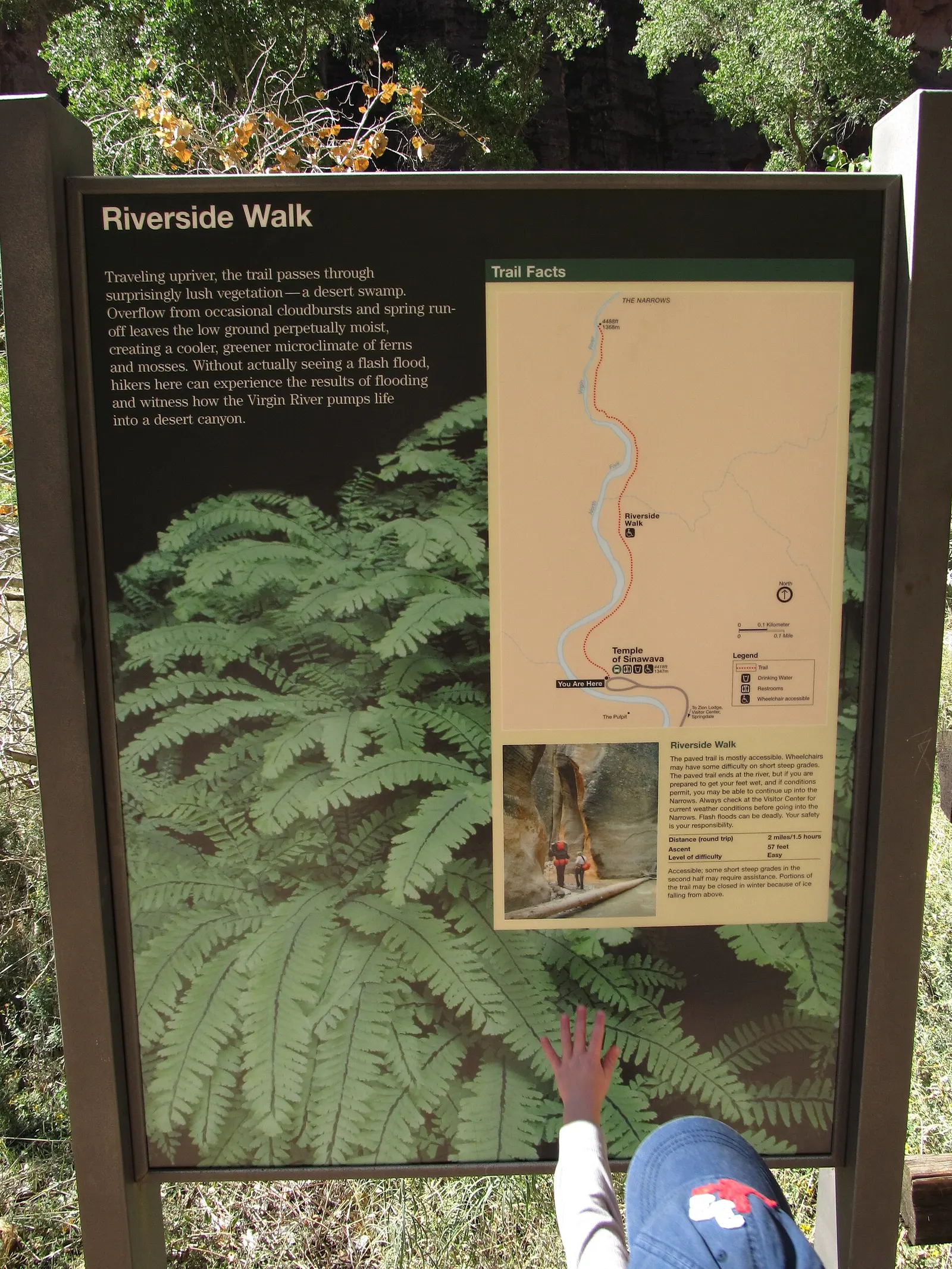
You follow the paved Riverside Walk to its end, then walk upstream in the Virgin River itself between canyon walls up to about 300 m (1,000 ft) high, with the river only 6-9 m (20-30 ft) wide in places. At least 60% of the hike is wading, walking and sometimes swimming, and you can turn back after an hour or carry on to Big Spring.
- Where
- Utah, USA
- Distance
- Up to 15.1 km (9.4 miles) return to Big Spring; the paved Riverside Walk alone is 1.6 km (1 mile) each way
- Climb
- 102 m (334 ft)
- Time
- 1-8 hours
- Difficulty
- Hard
The route
The Narrows from the bottom up: Riverside Walk from the Temple of Sinawava, then upstream in the Virgin River as far as Big Spring (day hikers turn round wherever they like before that).
The Riverside Walk starts at the Temple of Sinawava, shuttle stop 9 at the end of the Zion Canyon Scenic Drive. From March to November private cars are not allowed on the Scenic Drive, so most people ride the free park shuttle from the visitor centre, or the free Springdale shuttle from town.
When to go
Open all year while the river flows below 150 cubic feet per second; summer and early autumn usually have the lowest water, while spring snowmelt and late-summer monsoon storms often push the flow high enough to close it.
Permits and fees
No permit is needed to hike upstream as far as Big Spring; going beyond it, or more than 400 m (a quarter mile) up Orderville Canyon, needs a wilderness permit. The park entrance fee is $35 per vehicle for up to 7 days, and in 2026 each non-US resident aged 16 or over pays an extra $100 unless they hold an annual or America the Beautiful pass; the shuttle is free and needs no ticket.
Before you go
- Wear closed-toe shoes or boots and carry a sturdy walking stick; the park says sandals, crocs and bare feet often lead to twisted ankles and crushed toes.
- Check the river flow before you go: below 70 cfs the walking is moderately difficult, 70-150 cfs is challenging, and above 150 cfs the Narrows is closed.
- Use the toilets and fill your water at the Temple of Sinawava before you set off, as there are none in the river.
- Wear quick-drying layers rather than cotton to lower the risk of hypothermia, especially in autumn when the water gets colder.
What to bring
- Shoes with grip that you have already worn in
- At least 1.5 litres of water
- Food you will actually want to eat
- A warm or waterproof layer
- The route, saved offline
- Sun cream and a hat
Getting ready for it
Plan for a long day: 1-8 hours.
Build up with a few walks of four hours or more first, ideally with climbing and the pack you will carry. Step-ups and lunges twice a week make the descents easier on your knees.
Staying safe
- Flash floods can happen at any time. The Narrows closes during a flash flood warning and stays closed for at least two hours after the warning is lifted.
- The river rocks are slippery and uneven, water can be ankle to chest deep, and the park warns of toxic cyanobacteria as well as hypothermia.
- Tell someone your route and when you expect to be back.
- Turn around if the weather turns or the footing gets sketchy. The trail will still be there.
Route details checked September 30, 2026 against nps.gov, nps.gov, nps.gov, nps.gov, nps.gov, nps.gov and nps.gov. Rules and closures change, so check before you go.
.jpg)